

"Why are you still running the snowday forecast?"
Answering some obvious (see above) and not-so-obvious questions about the model and this weekend's storm.

*Certain data points may have changed since this article was written.
As recently as late last week, I have had to repeatedly answer one question regarding the snowday forecast: why is it still up? Each time I answered, I just said “we live in Wisconsin”. And just like that, mother nature decided to create the perfect storm this weekend. Some of you may remember that we actually had a snowday/closure two years ago in April, which was either the only or one of the only two closures that school year. Like I said, it’s Wisconsin. We truly are not in the clear from snow until May. And, this volatile, back-and-forth pattern of 60s to blizzards and back around again is only going to get worse and worse due to the effects of climate change. Just this week, we had elevated risks of severe storms, hail, and tornadoes, and now, we are dealing with a snowstorm. So, I thought it’d be a good idea to talk about this storm in particular, while using it to answer some broader questions about the model itself.
A “flaw” in the model that’s key to understanding why the odds keep changing
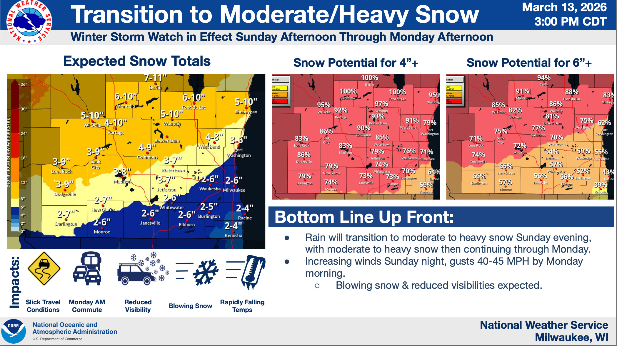
It’s important to note that although it’s called a forecast, the snowday model is really more of a “nowcast”, which is a predictive model for an event happening now, or in the immediate future. Of course, we are days away from this storm, and with weather forecasts in particular, things can and do change dramatically. Forecasting general trends or conditions, like temperatures, is far easier than a more exact metric like snowfall. That challenge is uniquely difficult with this system due to the current climate, because certain areas will be either just below or just above freezing, meaning it’s hard to tell exactly how much snow will stick on the ground. The NWS graphic below demonstrates how the shape of this storm is also so crucial.
Essentially, depending on which narrow band Madison falls under, we could receive 3-7 inches, or closer to 15 inches, and if the storm shifts dramatically south, which is unlikely but possible, we could get 20+. But, what’s the flaw in the model that this affects? As a nowcast, the snowday model has no factor and places no weight on time until the school day. It does account for time in a different way, where it grows less confident in a closure as hours pass by the night before. But it isn’t “aware” that we are predicting Monday vs. next Friday, for example. Our other models, like our election forecasts, have a time mechanism, where they both rely more on polling vs. fundamentals and grow more confident overall the closer we get to Election Day, but this does not. Basically, think of a 99.9% chance today as a 80% chance overall, whereas a 99.9% chance Sunday night is far stronger. These aren’t exact conversions, but you get the point: the swings you may see today and tomorrow will in theory get smaller and smaller the closer we get to Monday, because the NWS data will become more consistent, something our forecast is not inherently aware of.
How much snow are we actually going to get?
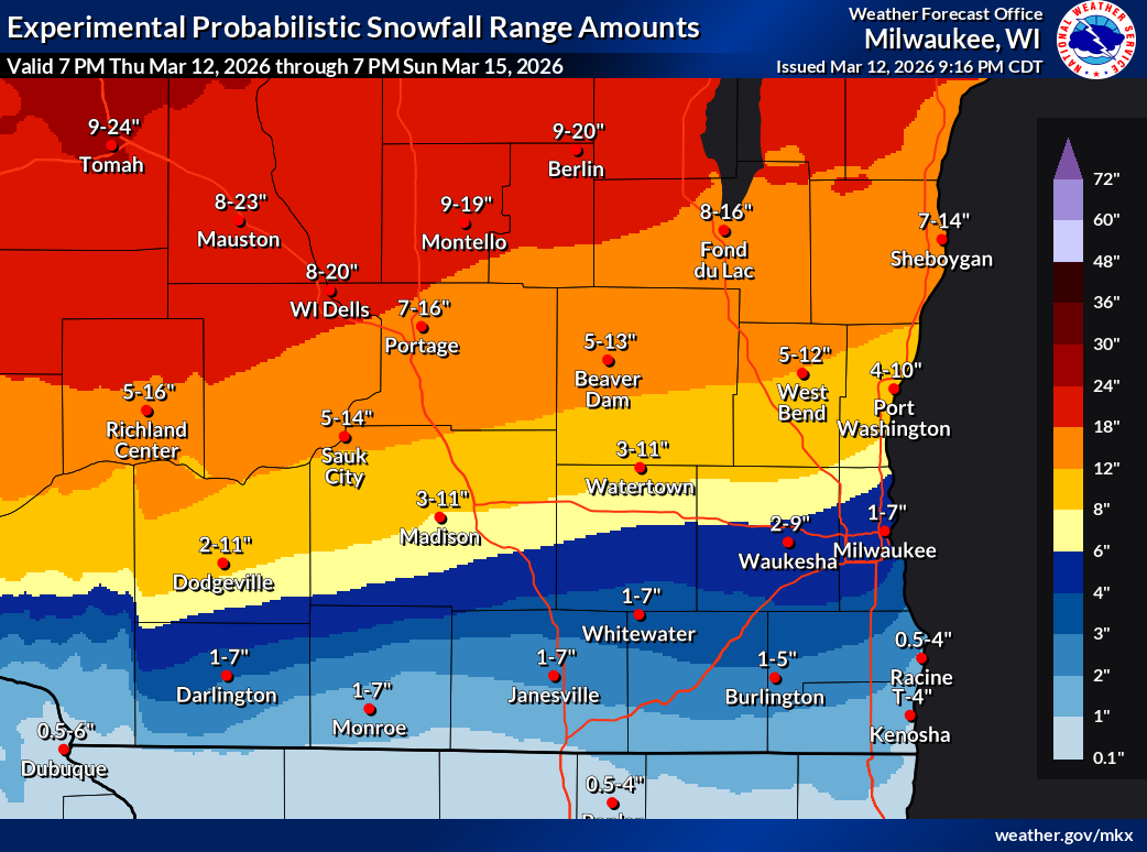
The short answer is that it’s still too early to tell. The better answer is that different models are saying different things. The GFS model, which has been consistent for the last few days, places us at a whopping 26 inches of snow by 7 AM Monday. The NWS hourly forecast, which is what our model uses, has us getting 15.1 inches total, up from 8 this morning, but down from 19 or so yesterday. Meanwhile, the NWS “probabilistic snowfall experiment” model has us getting anywhere from 2 to 9 inches. All in all, we simply don’t know yet.
What’s driving the model’s high chance of a closure?
The biggest threats that are contributing to a abnormally high chance of an MMSD closure are ice accumulation, snow depth, and wind gust speeds. MMSD typically has a threshold of 0.1 inches of ice, but the wind conditions and snow could lead to a Blizzard Watch/Warning that could prompt a day off as well.
When will MMSD call Monday off, if they do?
I think if we are still seeing double digit snow forecasts and ice accumulation, we will hear by noon-ish Sunday. If things calm down, it may be late Sunday night or very early Monday morning, but my bet is on Sunday.
More to come
I will be updating the forecast as best I can tomorrow, but admittedly it may be less frequent than normal as I have a forensics tournament. Keep an eye on things and our odds heading into Sunday, and let’s hope for another long weekend!