

Unprecedented Severe Weather Outbreak Expected Tomorrow (4/28)
Here's what to know as a massive storm system moves in tomorrow

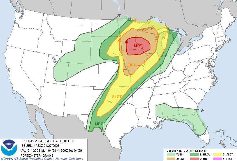
Although most weather-related posts that you’ll find on HDR Analytics may be about snow, I simply can’t not write about what the Madison-area, and the western half of Wisconsin as a whole will potentially experience tomorrow. For several days now, the National Weather Service and its Storm Prediction Center have been more confident about severe weather in our area than I’ve ever seen before. The categorical outlook has had a 30% chance of severe weather just shy of Madison multiple days out. That is uncommon for Madison, sure, as we usually see odds like that in the South or near Tornado Alley, but it’s also just uncommon in general. To put it bluntly: a day three (as in Saturday’s forecast for Monday) moderate risk has only happened 21 other times since the day three outlook was first introduced in the early 2000s. Translation: This is going to be hugely impactful, and will likely hit us hard.
Hail, hail, and more hail
As for the specific threats we should be watching for, hail has the highest odds here, with a 30% chance of any given area around Madison receiving hail. The latest update from the SPC is even worse for hail, as Madison is now within what we call the hatched area, meaning there is a “10% or greater probability of two inch diameter hail or larger within 25 miles of a point”.
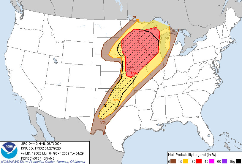
For context, two-inch hail is roughly between a golf ball and a tennis ball… If we do get hail near this size, expect significant damage to roofs, vehicles, and other structures. If you’re able, park your car inside tomorrow evening. If not, have Jake from State Farm on speed dial.

And tornadoes too!
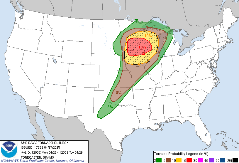
However, while hail is the most likely threat, it’s probably not the one you think of when you think “oh no, severe weather!”. Don’t worry, there’s a large tornado risk too. Madison sits right on the border of the 10-15% outlook for tornadoes. We are also in the hatched area on the tornado forecast, meaning there is not just a 10% chance of tornadoes, but a 10% or greater chance of EF2-EF5 tornadoes.
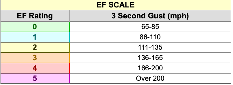
Above is the NWS scale for tornado speeds for each EF rating. Personally, I’d say anything over 80 mph is bad… but given there is even a remote possibility of an EF4 or EF5, it is absolutely crucial that you stay on alert tomorrow night when the worst of the storms move in. I plan to run a live broadcast and will post info on that tomorrow, as I pay for a premium radar service and can provide a bit of insight as things evolve. (Of course, if there are tornado warnings here, I have to move three floors down and won’t be able to do much other than post on the Instagram).
And some non-tornadic winds too
The final threat we face is straight-line winds from storms themselves. We are clearly in the 15% range for damaging thunderstorm winds or gusts of 50 knots (about 57 mph) or higher. I’m not overly concerned about damaging winds, and there is no hatched area here, so I’d say wind itself is the least of our worries.
Will anything actually happen?!
I. don’t. know. I can’t promise much more than the fact that we will get strong storms. I can tell you, based on both the data and how often these forecasts are right, that we will almost certainly see a Severe Thunderstorm Warning, very likely see a Tornado Watch, and some areas in and around Madison will get hail. What I don’t know is just how bad that hail will be, whether or not any of those tornado watches become warnings, etc. etc. But the odds are very good (or bad, I suppose) that we do see destructive hail or a few tornadoes, so please stay inside if possible and have a shelter-in-place plan, and stay updated on the latest developments. Although I have a never-ending list of complaints about local TV news, severe weather coverage is an area they continue to excel in, so if you don’t tune in here, do so there.
We should get a new NWS model in tomorrow morning, and I’ll post that on our Severe Weather Dashboard (linked below) as soon as possible. I’ll announce more details on the livestream tomorrow morning, so check back here then. It’s going to be a potentially wild ride tomorrow. Stay safe.
